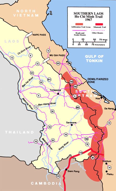
The Ho Chi Minh Trail (Vietnamese: Đường mòn Hồ Chí Minh), also called Annamite Range Trail (Vietnamese: Đường Trường Sơn) was a logistical network of roads and trails that ran from North Vietnam to South Vietnam through the kingdoms of Laos and Cambodia. The system provided support, in the form of manpower and materiel, to the Viet Cong (or “VC”) and the People’s Army of Vietnam (PAVN), during the Vietnam War. Construction for the network began following the North Vietnamese invasion of Laos in July 1959.
It was named by the U.S. after the North Vietnamese president Hồ Chí Minh. The origin of the name is presumed to have came from the First Indochina War, when there was a Viet Minh maritime logistics line called the “Route of Ho Chi Minh”,[1]: 126 and shortly after late 1960, as the present trail developed, Agence France-Presse (AFP) announced that a north–south trail had opened, and they named the corridor La Piste de Hồ Chí Minh, the ‘Hồ Chí Minh Trail’.[1]: 202 The trail ran mostly in Laos, and was called by the communists, the Trường Sơn Strategic Supply Route (Đường Trường Sơn), after the Vietnamese name for the Annamite Range mountains in central Vietnam.[2]: 28 They further identified the trail as either West Trường Sơn (Laos) or East Trường Sơn (Vietnam).[1]: 202 According to the U.S. National Security Agency’s official history of the war, the trail system was “one of the great achievements of military engineering of the 20th century”.[3] The trail was able to effectively supply troops fighting in the south, an unparalleled military feat, given it was the site of the single most intense air interdiction campaign in history.

